Building Beeing: A Modern Laravel Beekeeping Management System - Part 2: Google Maps & Weather API Integration
Theodoros Kafantaris
Published on August 14, 2025
In this second part of our series, we'll explore how Beeing integrates with Google Maps and OpenWeatherMap APIs to provide location-based features and real-time weather data crucial for beekeeping operations.
The Challenge of Location Management
Beekeepers often manage multiple apiaries across different locations, each with unique environmental conditions. Traditional spreadsheet-based tracking doesn't provide the spatial awareness needed for effective management. We needed to solve several key challenges:
- Precise Location Tracking: GPS coordinates for each apiary
- Interactive Map Selection: User-friendly location picking
- Weather Context: Environmental data for each location
- Performance: Efficient API usage within rate limits
Google Maps Integration Strategy
We chose Google Maps JavaScript API with the new AdvancedMarkerElement for several reasons:
- Superior mapping accuracy and detail
- Familiar user interface
- Advanced customization options
- Better performance than older marker systems
Interactive Map Creation Approach
Our mapping implementation focuses on three core scenarios:
1. Apiary Creation We created an interactive map where users can click to place their apiary location. The system provides:
- Click-to-place functionality with instant coordinate updates
- Draggable markers for precise positioning
- Real-time coordinate display in form fields
- Default centering on Greece for our primary market
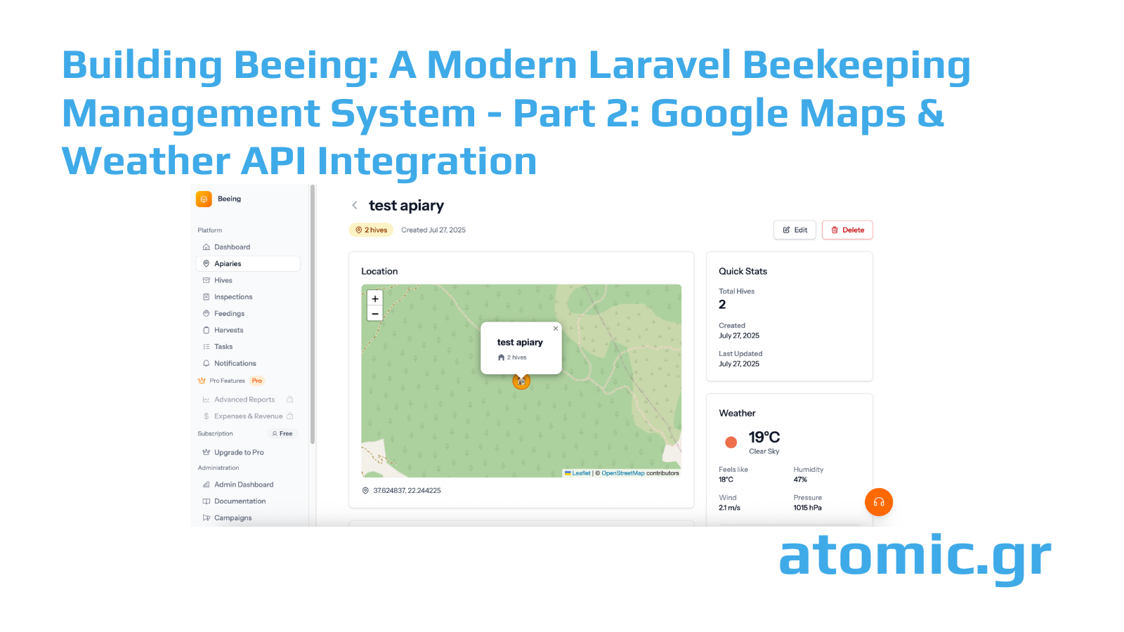
2. Location Display For viewing existing apiaries, we implemented:
- Static maps with custom markers
- Apiary-specific zoom levels for context
- Integration with the apiary information cards
3. Batch Operations For users with multiple apiaries:
- Overview maps showing all locations
- Clustered markers for dense areas
- Quick navigation between apiaries
Technical Implementation Highlights
The JavaScript implementation uses modern async/await patterns and error handling. We initialize maps lazily to improve page load performance and handle API failures gracefully.
Key features include:
- Responsive map sizing for all devices
- Touch-friendly interaction on mobile
- Keyboard accessibility for marker placement
- Graceful degradation when JavaScript is disabled
Weather API Integration Architecture
Weather conditions directly impact beekeeping decisions - from inspection timing to harvest planning. We integrated OpenWeatherMap for comprehensive weather data.
Service Architecture
We built a dedicated WeatherService class that handles:
- API authentication and rate limiting
- Data caching to minimize API calls
- Error handling and fallback scenarios
- Localized weather descriptions
Caching Strategy
Weather data follows a tiered caching approach:
- Current Weather: 30-minute cache (weather changes gradually)
- Forecasts: 3-hour cache (updated less frequently)
- Failed Requests: 5-minute cache to prevent API hammering
This strategy keeps our API usage well under the free tier limits while providing fresh data when needed.
Weather Data Processing
We process raw API responses to extract relevant beekeeping information:
- Temperature: Critical for colony activity levels
- Humidity: Affects nectar flow and disease pressure
- Wind Speed: Important for flight activity
- Precipitation: Impacts foraging and inspection scheduling
Display Integration
Weather information integrates seamlessly into apiary views:
- Current conditions with beekeeping-relevant metrics
- 5-day forecasts for planning purposes
- Weather alerts for extreme conditions
- Historical weather trends (future enhancement)
API Usage Monitoring
To maintain reliable service within API limits, we implemented comprehensive monitoring:
Usage Tracking
- Daily API call counters
- Per-user usage statistics
- Automatic alerts approaching limits
- Detailed logging for debugging
Optimization Techniques
- Smart cache invalidation
- Batch requests where possible
- Conditional requests using ETags
- Circuit breaker pattern for failed services
Error Handling & Resilience
Both mapping and weather services include robust error handling:
Graceful Degradation
- Maps fall back to coordinate input fields
- Weather displays cached data when APIs are unavailable
- User-friendly error messages explain temporary issues
Monitoring & Alerts
- Real-time API status monitoring
- Automated alerts for service disruptions
- Performance metrics tracking
- User experience impact analysis
Configuration Management
External API integration requires careful configuration management:
Environment Variables
We use Laravel's environment configuration for all API keys and settings, with sensible defaults for development environments.
Service Configuration
API endpoints, timeout values, and retry policies are configurable, allowing easy adjustment for different deployment environments.
Performance Impact
The integration of external APIs required careful performance consideration:
Page Load Optimization
- Maps load asynchronously after critical content
- Weather data fetches in background
- Progressive enhancement approach
- Lazy loading for non-critical components
Mobile Optimization
- Responsive map sizing
- Touch-optimized controls
- Reduced data usage on mobile networks
- Offline capability for cached data
Real-World Usage Patterns
After deployment, we observed interesting usage patterns:
- Most users place apiaries with high precision
- Weather data viewing peaks during inspection planning
- Mobile usage is significant for field operations
- Users appreciate the visual context maps provide
Lessons Learned
- API Rate Limits: Always plan for growth in usage
- User Experience: Progressive enhancement works better than all-or-nothing
- Caching: Smart caching dramatically improves performance
- Mobile First: Many beekeepers work primarily from mobile devices
- Fallbacks: Always provide alternatives when external services fail
In the next post, we'll explore the Stripe integration for subscription management and automated invoice generation through the Elorus API.
This is part 2 of our series on building Beeing. The integration of location and weather services demonstrates how external APIs can enhance domain-specific applications with real-world environmental data.


